

[ad_1]
Sprawling dumps of plastic waste can now be mapped from space thanks to a new tool using satellite imagery and artificial intelligence, in what is believed to be a world first.
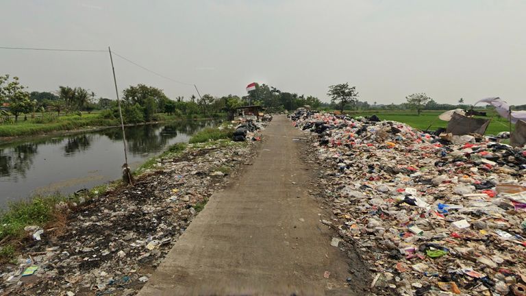
From a burning waste on a Sri Lankan beach to an Indonesian site seeping into a river, Global Plastic Watch (GPW) can detect sites as small as five by five metres, presenting them in an interactive global map of plastic in near real-time.
“It’s not about naming and shaming,” but “empowering governments,” with information to help tackle the problem, explained Fabien Laurier, a key architect of GPW.
The free, public tool, designed to help stop plastic from flowing into the ocean, has been “applauded” by the United Nations and is already being used by the government of Indonesia, the fifth highest contributor to ocean plastics.
“It is difficult to control what you cannot measure” or even locate, Kakuko Nagatani-Yoshida from the United Nations Environment Programme told Sky News. She hoped governments would use the “cutting-edge” technology to reduce “plastic waste littering and open-dumping and burning of waste”.
The street view function helps verify sites and whether they are leaking leaking plastic into the surrounding land and water. Pic: Maxar Technologies/Earthrise Media
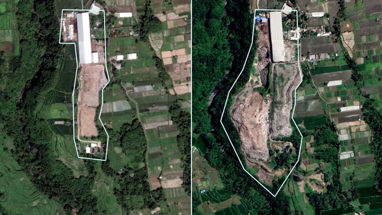
Historical records show how this site in Bali, Indonesia, grew significantly between 2014 and 2021. Pic: Maxar Technologies/Earthrise Media
Indonesian minister Ibu Nani Hendiarti said they had already used it to track down undocumented or illegal sites.
Every minute of every day, the equivalent of one truckload of plastic trash enters the world’s oceans, killing an estimated 100,000 marine mammals each year.
Identifying plastic waste sites ‘is totally novel’
Mr Laurier called plastic pollution “one of the greatest environmental crises of our time,” posing “tremendous environmental and human health issues”.
“And when it reaches the ocean, it breaks down into nanoplastics and essentially pollutes and contaminates the entire food chain,” he said.
Although a similar process is already widely used to track deforestation, data about plastic sites is generally based on models and estimates.
“Identifying the waste sites in the satellite imagery is totally novel and something that is very hard to do at all, [even] on a small scale,” Caleb Kruse, GPW’s lead data scientist, said on a video call from Berkeley, California.
Many of the identified sites are perfectly well-managed, while others are spewing out waste, the team says.

No barriers between this site and the water, GPW. Pic: Maxar Technologies/Earthrise Media
The team look for typical characteristics to identify plastic waste sites. The houses provide a sense of scale. Pic: Maxar Technologies/Earthrise Media
Mr Kruse’s team taught artificial intelligence to comb satellite imagery from the European Space Agency for “give-away” features of plastic sites.
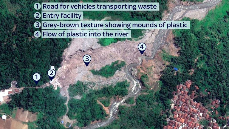
Sharing a screenshot of a site in Java, Mr Kruse picked out a road for trucks depositing the waste, an entry facility and grey-brown textured areas showing mounds of waste.
‘Enormous’ scale of some sites
“You can see that it’s almost like an avalanche of waste that [appears to be] just flowing right into that river,” he said.
To give a sense of the “enormous” scale of the site, he hovered his cursor over a house across the river, minute in comparison to the grey-brown sprawl of rubbish.
Just a “house-sized” amount of waste “can be really substantial”, he said.
Once identified, each location is then verified by a trained reviewer and cross referenced with other datasets to flag warning signs like proximity to waterways or people, or whether the soil type makes flow of plastic into the water more likely.
Pic: Global Plastic Watch/Maxar Technologies/Earthrise Media
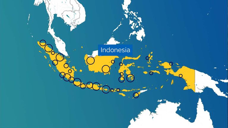
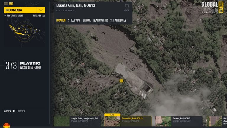
GPW has located hundreds of undocumented and illegal sites all over Indonesia, marked here in clusters
“The crazy thing is, we find sites like this all over,” Mr Kruse said, as he flashed up image after image of waste sites on his screen.
World’s waste hotspots
The interactive website has identified hundreds of waste sites across 26 countries, which account for more than 80% of the plastic in the world’s waterways.
Many of these countries will be processing waste that’s been exported by other countries, as well as their own. The UK ships off more than half its plastic waste every year. Western countries have their own “problems” with waste sites too, he said.
The process underpinning GPW is undergoing review for publication in a scientific journal.
Mr Kruse is clear-eyed about the fact the tool is not the “be-all and end-all dataset on plastic waste”, but hopes governments, NGOs and communities can use it as a starting point to hone in on the waste hotspots that need tackling first.
Watch the Daily Climate Show at 8.30pm Monday to Friday on Sky News, the Sky News website and app, on YouTube and Twitter.
The show investigates how global warming is changing our landscape and highlights solutions to the crisis.
[ad_2]